

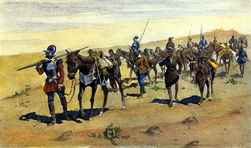
The first European to enter the Upper Rio Grande area and Sangre de Cristo Mountains was probably Francisco Vasquez de Coronado. In 1540 he started from Mexico City on his journey of exploration to the Pacific Ocean and through what is now Arizona, New Mexico, Texas, Oklahoma, and Kansas. A member of his army, Hernandao de Alvarado is credited with discovering Taos Pueblo, which he called Braba (19). He described the pueblo as having three stories of adobe and then another two to three stories made of wood. He estimated the population at 15,000, an exaggeration! Braba was visited by another contingent from Coronado’s army a few months later and these soldiers described two pueblos, one on each side of the river.
The pueblo was visited again by the Spanish in 1541 by Velasco de Varrioneuvo and the Spanish now named the location Valladolid. However, these explorers probably did not go further north than Taos. The 1580 expedition of Fray Agustín Rodríguez, which included two other friars and Captain Francisco Sanchez Chamuscado, and the 1581 expedition of Antonio de Espejo also only went as far north as Taos , as did the 1582 expedition of Antonio Espejo and Fray Bernardino Beltran. The lure of gold led Gaspar Castano de Sosa as far north as Taos in 1590 (20).
The first Spanish colonizers of New Mexico came with the Oñate conquest in 1598. Don Juan de Onate brought 130 soldiers and their families with him that year (a total of 400 men, women, and children, 83 wagons and carts, and 7000 head of cattle (21) and 80 more soliders in 1600. According to Fray Angelico Chavez, only 40 of these soldiers established permanent residence in this new land. At this point, the “Kingdom of New Mexico” (22) stretched from Taos Pueblo in the north to Guadalupe del Paso (Ciudad Juarez) in the south, west to the Hopi pueblos and east to Pecos, the Galisteo Basin, and the Manzanos Mountains.
The only Spanish town was Santa Fe. Oñate claimed all of the land drained by the Rio Grande for King Phillip II of Spain (23), although he is believed to have traveled only as far north as Taos (24). The Spanish government was quick to close the entire area to trade and exploration by other nations to protect their ownship of this vast area of the New World. The result was isolation both culturally and geographically (25).
Although Spanish explorers had come very close, the Questa area was still the domain of Native Americans. However, it seems clear that many Spanish explorers came through this area, mainly looking for gold. In 1593, Juan Humana and Francisco Borilla led an expedition to find gold mines “200 leagues north of Taos.” They did not return alive, but met their deaths at the hands of tribes along the Purgatory River, north of the Questa area in the Spanish Peaks area. However, others did find the workings of Native American mines and eventually a slave trade developed in the area to work these mines. The mines apparently were located near the Sangre de Cristo Pass, in the Culebra Mountains, and in the San Juans (26).
After the Pueblo Rebellion of 1680, sparked in large part because of the Spanish mistreatment of Indians working in their mines, Don Diego de Vargas re-established Spanish claims to the area in 1692. De Vargas describes in his campaign journal a 1694 expedition with a force of 70 soldiers north from Santa Fe into Colorado to investigate the Utes (27). Also accompanying the expedition were Franciscan missionaries, including Fray Juan de Alpuente and Fray Francisco de Farfan, believed to be the first Catholic priests to travel so far north in Spanish territory.
The purpose of the expedition was to raid Indian pueblos to obtain food for the 1100 “destitute” people living in the retaken Santa Fe and to subdue the rebellious Indians. He found Taos Pueblo deserted—the Indians had left on purpose to prevent the expedition from looting their granaries—and DeVargas set up crosses in the plaza between the north and south pueblos and then looted the granaries. De Vargas decided to return to Santa Fe north through Ute country and south along the Chama River to avoid being attacked by the Picuris Indians (28).
After being attacked by 80 Taos Indians north of Arroyo Hondo, the expedition made camp on July 8th, 1694 on the banks of the Rio Colorado (Red River) in the Questa area.
De Vargas wrote that he was informed that
“the mountains that run along the edge of the Rio Colorado are inhabited by Apaches del Acho, and that the Yutta nation, which we are looking for, does not countenance them in their land, for which reason I should flee from this place, which is also the farthest point to which the rebel Taos Indians, who still have sentinels and spies watching up, come out on the trail of the buffalo, the dung of which has been found in different parts, as along the descents from the mountain to the river.”
So here we have perhaps the first written description of the Questa area from the pen of De Vargas. De Vargas and his men then marched north to the Culebra River and then turned west and crossed the Rio del Norte. They traveled to the San Antonio River and then south past San Antonio Mountain along the west side of Rio del Norte and back to Santa Fe. While they were in the San Antonio Mountains, they were attacked by Utes, and De Vargas’ description of the event is interesting because it describes the status of the Utes at that point (29).
“There were about three hundred of them counting the women. Their apologetic explanation of the reason for their raid was quite plausible. They pointed out how before the revolt of 1680 they had been the friends of the Spaniards, but had always been enemies of the Tewas, Tanos, Picuries, Jemez, and Keres. During the period of pueblo independence these rebels has often come to this region to hunt buffalo disguised as Spaniards mounted, and with leather jackets, leather hats, firearms, and even a bugle, all of which they had taken from the Spaniards at the time of the revolt. Whenever they went on these excursions the Utes had attacked them, hence the recent misfortune, a result of mistaken identity. The expedition departed with manifestations of friendship on both sides, and the Utes were invited to Santa Fe to trade with the Spaniards as had been their custom prior to 1680.”
Spanish settlements were established along the Rio de Norte (Rio Grande) from Taos Valley south to Tome. Two more Spanish cities resulted as well—Santa Cruz de la Cañada and Albuquerque. In 1694 De Vargas traveled through the Questa area to re-establish a mission in the San Luis Valley that would open the way for mining and Indian slavery to resume.
Other expeditions through this area included the 1692 expedition of Captain Roque de Madrid—the first military expedition in northern New Mexico. He returned in 1705 to lead an expedition north from Taos to retrieve runaway slaves. In 1706 (30) Captain Juan de Uribarri traveled through the Jicarilla Apache lands of northeastern New Mexico to the furthest northern limits of Spanish control chasing after runaway slaves, where he met French fur traders. He claimed the Northern Rockies and nearby areas in the name of the Spanish king (31). In 1719 Governor Valverde went on expedition to punish the Utes and Comanches, who were raiding Apache settlements (32). He left Taos with a force of 105 soldiers and over 400 servants and warriors. They found that the French were making inroads on territory in what is now southeastern Colorado, even supplying the Indians with firearms, but apparently the worst of their experiences was a serious attack of poison ivy (33).
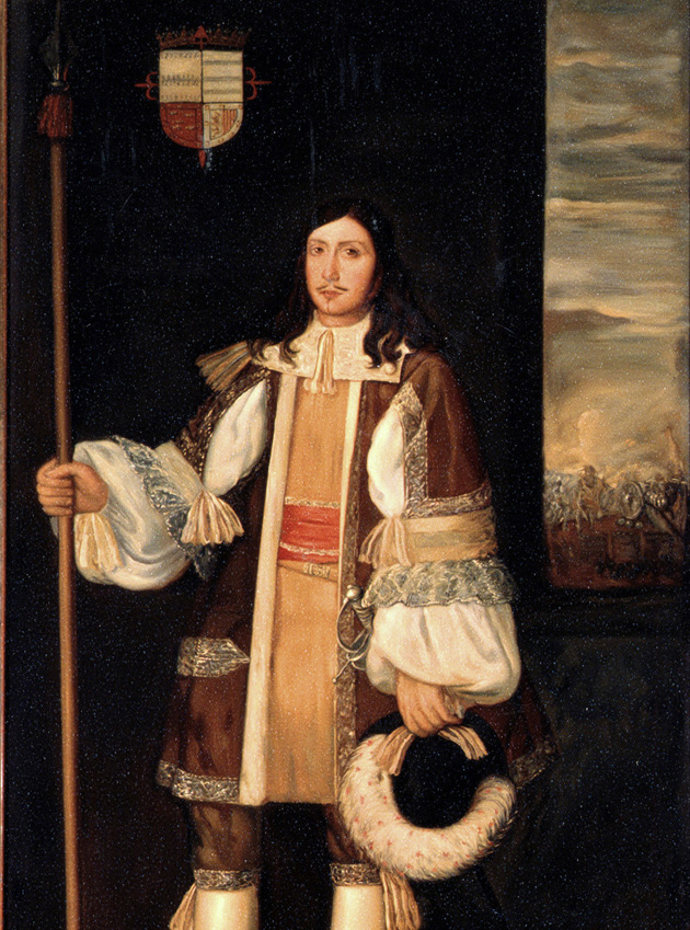
French and British traders in the Questa area were becoming a problem for Spain, threatening Spain’s sovereignty in New Spain. In 1720 (34) Don Pedro de Villasur was sent north to Colorado and Wyoming—also later to Kansas and Nebraska— to deal with this threat. One message had reached Santa Fe that 6000 Frenchmen were only 175 miles from Santa Fe (34)! Villasur left Santa Fe with 40 soldiers and 60 or so Pueblo Indians and Apache guides (35) and then took the route to Taos and east over the mountains. The fate of this expedition was quite different, with most of the men, including Villasur scalped by Pawnee Indians near the North Platte River, in 1720.
We actually have pictorial evidence of Villasur’s exploits in the Segesser II hide painting, which were collected by the Jesuit Padre Felipe Segesser. Although the artist is unknown, the paintings are the earliest known pictures of the Spanish colonial presence in the southwest. Villasur is shown at the Battle of August 20, 1720, the ambush of his party of Spanish soliders and pueblo Indians (36).
Many of these early explorers seemed to skirt the southern San Luis Valley area by crossing over the mountains to the east just north of Taos at Fernando Creek, and then along the eastern foothills of the Sangre de Cristo Mountains, although those headed for the mines in the San Luis Valley most probably came up through the present Questa area. The most common route north was said to be from Santa Fe to Taos, then north until the the Culebra Mountains could be crossed to the east, and northeast to valley of Purgatoire River, or north by way of San Luis Valley.
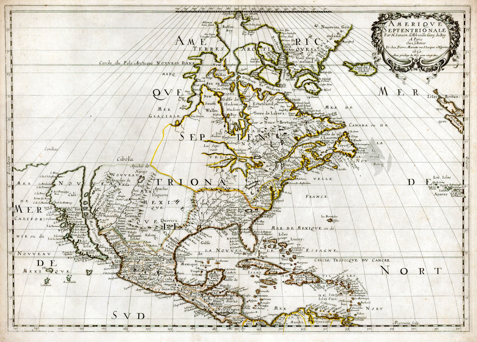
The arrival of the French in this area was imminent, if it had not already occurred— Villasur had already encountered French traders near this area. However, the French did not seem to be very interested in the Questa area at this point. A French map by Guillaume de L’Isle in 1718 (see Figure 8) shows North America from the East Cost to the Rio Grande. Taos appears on the map as does Picuris Pueblo, but the Rio Colorado of the Questa area does not appear and Indians to the north of this area are labeled Padoucas; east of the mountains is labeled country of the Apaches and the Padoucas (37). However, the Spanish continued to worry about French entry into the Territory of New Mexico (38). The Viceroy of New Spain wrote Governor of New Mexico in 1719 to take care to win over Apaches to Spanish allegiance so that this alliance would prevent the French from coming into Spanish territory. This strategy was so important to Spain that Spanish gifts to Indian tribes in 1700s cost in some years as much as $100,000—a huge amount of money in that period!
This strategy worked until the mid-18th century when the French persuaded the Comanches and Apaches to let them pass through. The pressure of the French was too great and, in 1739, the Mallett brothers Pierre and Paul entered New Mexico and were allowed to sell their trade goods in Santa Fe; the French returned in 1749 and 1750-1. Soon after in 1763, Louisiana was transferred to Spain, which moved the Spanish frontier east to the Mississippi River.
The search for gold and silver north of the Questa area continued to bring travelers through this area. In 1761 Governor Manuel Portillo explored San Luis Valley for minerals (39), and in 1768, the expedition of Don Juan Maria de Rivera traveled up from Santa Fe through the Chama River area and them back down through San Luis Valley. To protect their explorations and mineral finds, the Spanish built a fort on San Antonio Mountain in 1768.
Spain made peace with the Comanches around 1783. The gift-giving system to Indians was firmly established at this point, so much so that Pedro Bautista Pino, in his 1812 report to Spain notes that the Utes possess “…a stronger tendency toward brigandage than toward acquiring recognition through virtuous acts. Their hypocrisy leads them to perpetuate acts of the most abject humiliation. Money is all powerful with the Yuta” (40).
The next written description of the Questa area comes from the journals of Don Juan Bautista de Anza, Governor and Military Commander of New Mexico, in 1779. He was on his way back from the Battle of Greenhorn in Colorado, in which he killed the Comanche Chief Cuerno Verde (“his haughty and arrogant manner caused me to resolve to deprive him of his life”) south of the present Pueblo, Colorado, when he passed through this area. The Comanches had been harrassing the Spanish settlements and pueblos of of northern New Mexico and Anza, along with an army of 800 men (including 200 Utes and Apaches) and 2500 horses was sent to push them back (41).
After the battle with the Comanches on September 3, 1779, Anza turned south to return to Santa Fe. He reached the Rio de la Culebra on September 5th. The Utes, who had traveled with Anza left here “…without bothering to say good-bye, this lack of attention to the amenities due either to their barbarity or to their eagerness to be back on home ground” (41). On Tuesday, September 7th, Anza describes his travel through the Questa area. “A little before seven we started out and marched for three leagues over good terrain before crossing the Rio Colorado, then we skirted the mountain on our left, and where the going was a bit rough, and so it took us until four o’clock to make the remaining five leagues to the Pueblo de Taos, which is the farther north of any village in this territory.” Anza helped repel an attack by Apaches at Taos before traveling back to Santa Fe.
Pressure by the Indians continued to hold back Spanish settlement on the northernmost frontiers of the New Mexico Province, but despite these continued incursions, the Province of New Mexico continued to grow. In his General Report of 1781, Don Teodora de Croix, commander general of Interior Provinces of New Mexico noted that the population of the Province of New Mexico was 20,810 people. Of the Indians, he reported “The Comanche and all the Apache, with the exception of the Navajo and Jicarilla, now at peace, attack in this province…the numerous and valiant Ute nation remains friendly and aids us happily against the Comanche.” Later he analyzes the Indian situation, which is impeding resettlement of the Province—“I shall content myself if the Comanche make less frequent visits to the territories of New Mexico, if the Ute remain faithful to our friendship, and if the Navajo do not take sides openly in the interests of the Apache. In this way the hostilities of the latter can be withstood and punished, and the province will breathe” (42).
The northern frontier of New Spain was in many ways a burden to Spain in the early 18th century. The Presidios in the south from the Gulf of Mexico to the Gulf of California were manned by about 5000 soldiers and Indian allies. There was inadequate financial support from Mexico City and Spain to bring the Interior Provinces of New Spain under control. In addition, during the 18th century and early 19th century Spain was engaged in the War of Spanish Succession, the War of Austrian Succession, the Seven Years War, the American Revolution, a war against England, and a war against Napolean! Thus the northern settlements were left to their own devices in defending against Apache and Comanche raids. According to Brinkerhoff and Faulk (43), The Interior Provinces included the area along the Rio Grande. There were no presidios in New Mexico—just missions and civil settlements. In civil settlements, land ownership included the obligation to maintain arms and horses to assist the military because Spanish government envisioned the civilian population as a standing militia
But the militia in the Borderlands did not have proper training or leadership. As described by Brinckerhoff and Faulk (44), “They lived secure within the solid adobe walls of their forts, drew their rations and pay, and farmed the small plots of land assigned to them. Along with the civilians, the chief concern of the soldiers was to stay alive on that bloody frontier—and, hopefully, to reach retirement age.” Such was probably the life of the small contingent of soldiers and settlers visited by Jacques de Mun on the Rio Colorado in 1816 (see below).
Notes
19. Bolton, H.E. Coronado: Knight of Puebblos and Plains, University of New Mexico Press, Albuquerque, 1949.
20. Thomas, A.B., Spanish expeditions into Colorado. The Colorado Magazine I, 289-300, 1924; Weber, David J. (ed.) New Spain’s Far Northern Frontier: Essays on Hispanos and Indians in the American West, 1540-1821. University of New Mexico Press, Albuquerque, 1979.
21. Thomas, A.B. Spanish exploration of Oklahoma 1599-1792. Chronicles of Oklahoma 6(2): Juen 1928.
22. Chávez, Fray Angelico. Origins of New Mexico Families in the Spanish Colonial Period. The Historical Society of New Mexico, Santa Fe, 1954.
23–24. Thomas, A.B., Spanish expeditions into Colorado. The Colorado Magazine I, 289-300, 1924.
25. Warren, N.H. Villages of Hispanic New Mexico. School of American Research, Santa Fe, NM, 1987.
26. Simmons, Virginia McConnell. The San Luis Valley: Land of the Six-Armed Cross, 2nd ed. University Press of Colorado, 1999
27. Espinosa, J. Manuel. Journal of the Vargas expedition into Colorado, 1694. The Colorado Magazine XVI:81-90, 1939.
28. Espinosa, J. Manuel. Governor Vargas in Colorado. New Mexico Historical Review XI,178-187. 1936; Espinsoa, J. Manuel. The Colorado Magazine 11:179, 1936
29. Espinosa, J. Manuel. Journal of the Vargas expedition into Colorado, 1694. The Colorado Magazine XVI:81-90, 1939.
30-31. Thomas, A.B. Spanish exploration of Oklahoma 1599-1792. Chronicles of Oklahoma 6(2): June 1928; Thomas, A.B., Spanish expeditions into Colorado. The Colorado Magazine I, 289-300, 1924.
31. Lost Treasures of Utah. www.xmission.com/~jbdaniel/spanish.htm, accessed 8/26/03.
32–34. Thomas, A.B., Spanish expeditions into Colorado. The Colorado Magazine I, 289-300, 1924.
35. General Don Pedro Villasur sent to Nebraska in 1720. www.nebraskastudies.org/0300/ stories/0301_0113.html, accessed 3/16/03.
36. Bachrach, Arthur J. Early representations of storytelling: rock art , hides, and ledger sheets. In Art of the Book in the Southwest. Millicent Rogers Museum, Taos, NM, 2003, p 7.
37. Guillaume de L’Isle map. LOC 2001624908.
38. Thomas, A.B. Spanish exploration of Oklahoma 1599-1792. Chronicles of Oklahoma 6(2): Juen 1928.
39. The Culebra River Villages of Costilla County, Colorado. National Register of Historic Places. Multiple Property Submission. U.S. Department of the Interior, National Park Service. Valdez and Associates, 2000 and Office of Archaeology and Historic Preservation, Denver, Colorado.
40. Pino, Pedro Baptista. Three New Mexican chronicles: the Exposicion of Pedro Bautista Pino 1812; the Ojeada of Antonio Barreiro, 1832; and additional by Jose Augustin de Escudero, 1849. Translated with introduction and notes, but H. Bailey Carroll and J. villasana Haggard. Quivira Society, Albuquerque, 1942.
41. Diary of Governor Juan Bautista de Anza, 1779. Translator Edgar Bledsoe, Editors Ronald E. Kessler and Donald T. Garate, http://anza.uoregon.edu; Miller, Ione. Juan Bautista de Anza and the Battle of Greenhorn. Pueblo County Historical Society, http://www.Pueblohistory.org/history. anza.htm
42. Thomas, Alfred Barnaby. Teodoro de Croix and the Northern Frontier of New Spain, 1776- 1783, From the Original Document in the Archives of the Indies, Seville. University of Oklahoma Press, Norman.
43–44. Brinkerhoff, Sidney B. and Faulk, Odie B. Lancers for the King: A Study of the Frontier Military System or Northern New Spain, with a translation of the Royal Regulations of 1772. Arizona Historical Foundation, Phoenix, 1965.